This blog entry is a 2-part article published simultaneously, but to fully appreciate and understand the one you must read the other (and vice versa). My research buddy, Don Casada, and I teamed up to write about one of our favorite projects thus far - the placement of a cenotaph for Nellie Martin, a Cherokee woman who lived and died in the Deep Creek/Indian Creek area. We have spent countless hours in the research and writing of these pieces, revising many times, but the resulting articles are ones which we hope will honor Nellie's legacy and the legacy of other Cherokee who inhabited the area but are "known only to God". I wrote this article, which is focused primarily on what is known about Nellie and her family.
________________________________
Back in 2011, when Don Casada and I first started our historical research on home sites in the Swain County portion of the Great Smoky Mountains National Park, we made a couple of trips to the park's archives, which at the time were located in a basement of the park headquarters at Sugarlands. Annette Hartigan, the archivist at the time (now retired) was an enthusiastic supporter of our research and was always well prepared for our visits with items she thought we might find of interest.
.jpg) |
| Figure WM1: The two cabins at the Bumgarner place, approximately 1.7 miles from the Turnaround. According to park records, the smaller cabin was built by Indians. It is likely very similar to Nellie's cabin at the Turnaround. (Source: Open Parks Network) |
On one such trip, she pulled out several field notebooks kept by Charles Souder Grossman (Figure WM2), an architect who, during the 1930s and 1940s, worked with historian Hiram Wilburn to document the homes and artifacts left behind by former residents of lands that became the Great Smoky Mountains National Park. We found many exceptionally interesting facts amongst his notes, but one entry in particular stood out, for it detailed a conversation Grossman had with Will Jenkins, who lived in a home across the last bridge on Deep Creek at the current intersection of the Deep Creek Trail and the Loop Trail.
 |
| Figure WM2: Charles Souder Grossman. (Source: Open Parks Network) |
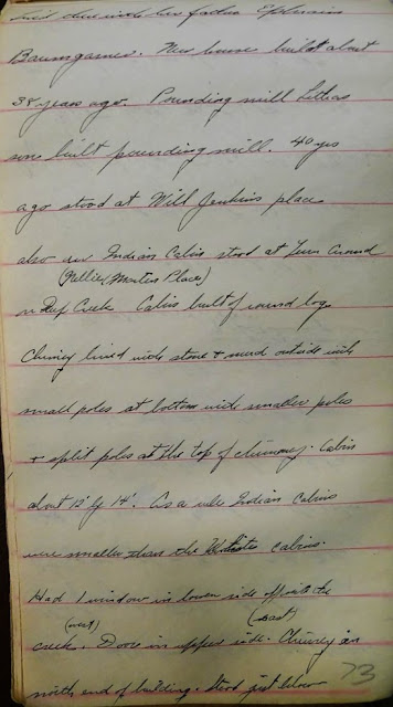
I have included a picture of the first page of the relevant notes below (Figure WM3), but they are not particularly easy to read and I have provided a verbatim transcription below, courtesy of Don.
Lived there with her father Ephraim
Baumgarner. New house built about 38
years ago. Pounding mill Litha’s son
built pounding mill. 40 years ago stood
at Will Jenkins place.
Also an Indian Cabin stood at Turn Around
(Nellie Martin Place) on Deep Creek Cabin built of round log. Chimney lined
with stone & mud outside with small poles at bottom with smaller poles
& split poles at the top of chimney.
Cabin about 12’ x 14’. As a rule
Indian cabins were smaller than the White cabins. Had 1 window in lower side opposite the creek
(west). Door in upper side (east). Chimney in north end of building. Stood just below two big apple trees which are
still standing. Floor of rough
lumber. Got it from a little saw mill on
Indian Creek. Nellie died and was buried
near the cabin. She had her crib keys in
her pocket and was buried with them. The
crib door was never opened but a new door was cut in the other end. Crib stood below house of split chest logs
about 8’ x 5’.
Will Jenkins place built by George Jenkins
his Daddy about 30 years ago. Originally
the Corntassle Place (Indian.
Went to Nellie Martin Place with Mr.
Jenkins & was shown site of Indian Cabin & crib also Nellie Martins
grave.
 |
| Figure WM3: May 14, 1937 notes on Nellie Martin captured by Charles Grossman. This is one of three pages from which the above transcription is taken. (Source: GSMNP archives) |
 |
| Figure WM5: 1884 Hester Roll - entry for Nellie (solitary line on top) and her brother George and his wife (bottom). (Source: National Archives, Image M1773-09-013) |
 |
| Figure WM6: 1880 Census showing the George Martin household. (Source: Ancestry.com) |
- The family was headed by the unmarried George, age 20
- Nellie was reported to be an “idiot” and “insane”; perhaps suffering from a mental illness or a neurological disorder affecting her brain (for those interested, here is an interesting article on the categorization of such individuals in this particular census)
- Her elderly mother Nancy is also listed as being an “idiot”. In light of Nancy’s advanced age, senile dementia is a not implausible reason for having been assigned this classification.
- Jonas Martin is a 6 year old child in a household in which the women may have been unable to care for him.
The land granted to Nellie was much further downstream
of the Bryson Place and closer to assistance should the family have needed it.
T.D. Bryson was known to have been a generous community benefactor and may well
have chosen to provide for what he saw as a family in significant distress.
Grossman’s records show that after receiving this gift, the Martins built (at minimum) a small cabin and corn crib and also planted apple trees that were still standing in 1937, when Grossman talked with Will Jenkins. They likely farmed the land in the Turnaround (Figure WM7), some of the very little relatively flat and arable land in the area.
 |
| Figure WM7: The Deep Creek Turnaround as it looked in 1937. This picture was likely taken from very close to the Hunnicutt home, which Don and I believe to have been the prior site of the Martins' home. (Source: Open Parks Network) |
 |
| Figure WM8: The likely location of Nellie's burial on Indian Grave Ridge just above the Turnaround, where Marion and Columbus Hunnicutt are known to be buried. Susan Casada is standing at their graves and I am standing where the Hunnicutt home was known to be (some of the foundation stones are still there) and where we believe the Martin cabin to have been located. A detailed map of the Turnaround area is shown in Figure DC 13 in Don's piece. (Photo credit: Don Casada) |
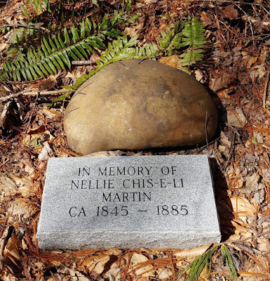
I would encourage interested readers to visit Nellie’s cenotaph (Figure WM9). The Turnaround is located approximately 2.1 miles from the gate at the main Deep Creek trailhead, by following the main Deep Creek Trail. The stone is located in the middle, approximately two-thirds of the way to the far end of the Turnaround in the middle and is visible from the trail (more easily visible in winter).
Over our lifetimes, Don and I have been at the Turnaround hundreds of times – never knowing, until 2011, the fascinating history that lay just fifty feet away from us. Of all the historical work I have done, the work associated with memorializing Nellie Martin ranks exceptionally high on my list. While the white settlers of the Deep Creek section of the park are relatively well-documented, quite the opposite is true for the Native Americans who lived in the area prior to that time. Evidence of their existence there has come only in the form of a few found arrowheads and pipes, a couple of graves on Indian Creek that are believed to have Cherokee-language inscriptions on them (Figure WM10), references to home places such as the June Whank and Corn Tassel places, maps of reserves taken out in conjunction with the 1819 Cherokee cession treaty, and interviews with descendants of the original white settlers who had told their grandchildren that Indians were living on the creek at the time they moved there. The research we have conducted to give personhood to an individual who has, heretofore, resided only in a few census roll lines, represents an important step in establishing a far more complete human history of Deep Creek. |
| Figure WM10: Gravestone with what are believed to be Cherokee language engravings; Parris Cemetery on Indian Creek. (Photo credit: Don Casada) |
 |
| Figure WM11: The Indian Cemetery on Deep Creek near the Will Jenkins homeplace (above the last bridge on Deep Creek). (Photo by the author) |
_________________________________
Sources:
Ancestry.com
Fold3.com
Great Smoky Mountains National Park Archives
Individual Contributors: Don Casada, Annette Hartigan,
Mike Aday, Frank March, Heath Bailey, Susan Casada, Jim Casada
National Archives and Records Administration (Mullay
Roll [1848] Siler Roll [1851], Chapman Roll [1852], Swetland Roll [1869],
Hester Roll [1884]. An excellent description of what was collected by the
various rolls can be found at this link: Eastern
Cherokee Census Rolls, 1835-1884 (archives.gov)
Open Parks Network.org
Swain County Register
of Deeds


No comments:
Post a Comment