This blog entry is a 2-part article published simultaneously, but to fully appreciate and understand the one you must read the other (and vice versa). My research buddy, Don Casada, and I teamed up to write about one of our favorite projects thus far - the placement of a cenotaph for Nellie Martin, a Cherokee woman who lived and died in the Deep Creek/Indian Creek area. We have spent countless hours in the research and writing of these pieces, revising many times, but the resulting articles are ones which we hope will honor Nellie's legacy and the legacy of other Cherokee who inhabited the area but are "known only to God". This article was written by Don and is focused primarily on the geography and history of the area in which Nellie and her family lived.
________________________________________
In 1859, more than two decades after the
bitter Trail of Tears, three men from Waynesville – R.V. (Robert Vance) Welch,
W.W. (William Wayne) Battle, and J.R. (James Robert) Love – paid $5,000 for
50,000 acre North Carolina Land Grant (LG) 587, a boundary which covered the
majority of the land between the upper section of Oconaluftee in the east and
Welch Divide in the west. Parts or all
of entire major and minor drainages were within the boundary, as illustrated in
Figure DC1.
 |
| Figure DC1. N.C. Land Grant 587 boundary – from Forney Creek to Oconaluftee. (Map by author) |
But a transaction of principal interest
here involves the sale by the grantees and their heirs of 1100 acres in the
very heart of Deep Creek – the Bryson Place – and an interconnected 100-acre
purchase a few miles downstream.
Will Thomas and T.D.
Bryson strike an agreement
On September 21, 1868, Will Thomas signed an agreement
which read:
I
agree to let Col. Thadeus (sic) D. Bryson have the unimproved Martin tract of land on Deep Creek,
including one hundred acres to be run in a square or oblong square to include
the Martin improvement for the sum which the land and improvements may be
valued to be worth at green back prices by John Millsaps, Wm Cathey, & Lt.
Wm Morris or a majority of them.
And
I agree to make a title for said land to the said Bryson or his Assignee upon
credit being given on our own contract.
Green back rates
Sept.
21 1868
Wm.
H. Thomas
We
the undersigned referees have examined the Land and value the same at one
hundred and fifty dollars in Green Back.
Oct.
24th 1868 Wm.
L. Morris
John
A. Millsaps
Wm.
H. Cathey
The wording of the agreement is confused – Thomas
agreed to let Thaddeus Dillard (T.D.) Bryson acquire an unimproved
Martin tract which included the 100 acres of the Martin Improvement – an
utter non sequitur. As we’ll see, the apparent
intent was to express his willingness to sell 100 acres of land which had been
improved by the Martins, with the improved section accompanied by an
unspecified area of unimproved land.
The Martin Improvement would later be known as the
Bryson Place. A photo of the Bryson
Place cabin taken almost 70 years later (1937) by Charles Grossman is shown in
Figure DC2. Clearly, instead of a single
cabin, it is actually two cabins built at different times, with a small gap in
between the outer walls, but connected by an internal passageway. While the portion on the left has stovepipes
sticking out the roof, it originally had only a chimney at the far left. Could one of these two sections have been the
cabin of the Martin Improvement?
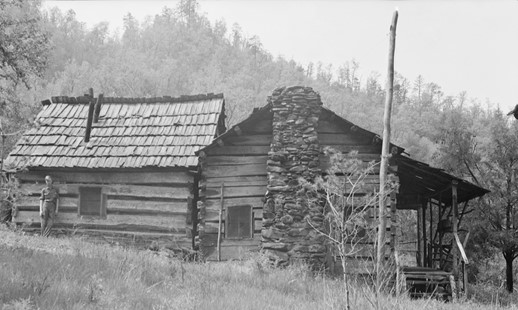 |
Figure DC 2.
Bryson
Place from the north.
Open Parks Network |
Another, more likely possibility, appears in a photo
from the Horace Kephart Special Collection at Western Carolina’s Hunter Library
shown in Figure DC3. The smaller
structure in the foreground of this undated photo (likely around 1910) does not
appear in later photographs of the Bryson Place. The small, south-facing window is similar to
that of the smaller Bumgarner cabin shown in Figure WM1 in Wendy’s accompanying piece.
As noted by Charles Grossman, that smaller cabin was Cherokee-built, and
the same may very well be true here. The
fruit trees, both in the foreground behind the unknown couple and in the left
background, beyond the cabin, appear large enough to be several decades old.
 |
| Figure DC3. Bryson Place, from the south. Southern Appalachian Digital Collections, Hunter Library |
Regardless of which – if either – of the cabins in these photos was erected by the Martins, in 1868, they were clearly living at the place which Thomas agreed to sell, had been living there long enough to have cleared the land, build a cabin, and made the other necessary changes to warrant the title “Martin Improvement.”
It seems entirely possible that the confused wording in
the agreement was a result of Will Thomas’s dementia; he was declared insane
the year before signing the agreement.
Less than two years later, when the 1870 Jackson County census was
recorded, 64-year old W.H. Thomas was the first person listed in the Qualla
District. His profession was given as
State Senator, Merchant & Farmer. In
the column reserved for identifying ailments, he was listed as “Insane.” Thomas had formerly served as State Senator,
but was not serving in 1870, and in fact had not served in that capacity since
1862.
All of the individuals named in the agreement would
have been well acquainted The three
referees – Billy Morris, John Millsaps and William Hillman “Hill” Cathey – were
all residents of the Deep Creek area.
Millsaps was a physician; Morris and Cathey had served in the Civil War
and were brothers-in-law (Cathey’s wife was Nancy Morris, sister of Billy). Millsaps and Morris in particular owned
considerable lands on Deep Creek.
Cathey’s place on Indian Creek was relatively small in proportion, but
was still in excess of 150 acres. Bryson
and Thomas would have been well acquainted, as both had represented Jackson
County in the state legislature (Bryson in the House, Thomas in the
Senate). Hill Cathey served in Thomas’s
Legion during the Civil War.
The agreement which Thomas signed wasn’t proven until fifteen years later, when Probate Judge W.A. Gibson approved it on Nov. 3, 1883 and it was registered the same day by Nathan Byers Thompson, Register of Deeds. This delay may have been a factor in the next subject – duplicate deeds.
 |
Figure
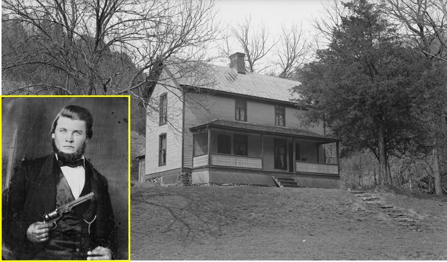
DC4. Billy Morris, home place. This site is located just above the parking lot at the gate to the Deep Creek trail. Morris
photo courtesy of Jim Estes. Home photo: Open Parks Network |
On May 23, 1878, T.D. Bryson purchased 1,100 acres of
land on Deep Creek in two separate tracts – a 1,000 acre tract and a 100 acre
tract. The boundaries were not
defined. The deed read:
The
undersigned do this day sell to TD Bryson one thousand acres of land on Deep
Creek in Swain County and adjoining lands lately purchased from Wm H Thomas and
now occupied by Samuel Elliott at 33-1/3 cents per acre
and also one hundred acres adjoining Geo. Shuler on Deep Creek where Joe
Feather lives at one dollar and fifty cents per acre and we authorize E Everett
to make deeds in pursuance to a power of attorney now effected reserving ¾ of
the minerals in the lands this 23rd of May 1878. The said parties acknowledge the payment therefore
by a credit of one hundred and twenty dollars on RV Welch’s note and three
hundred and sixty three on Samuel L. Love’s note to be surveyed at the costs of
the undersigned this 23rd May 1878.
Atest
(sic) RV
Welch
E
Everett RGA
Love
W.L.
Hilliard
RM
Henry Saml
L Love
The wording of the deed is – somewhat like the
agreement language – jumbled in that it says the one thousand acres adjoins
lands lately purchased, yet the adjoining one hundred acres is specified
after the thousand acres in the deed.
Regardless, the 100 acre tract is clearly the same one referred to as
the Martin improvement in the 1868 agreement; the price is that indicated by
referees Billy Morris, Hill Cathey, and John Millsaps. It is noteworthy that in the ten years since
the agreement signed by Thomas, Samuel Elliott had begun to occupy the
unimproved section and Joe Feather (a Cherokee man) was then living on what was
previously described as the Martin improvement.
No record has been found of George Shuler owning land within miles of
this area. Joe Feather and his family are mentioned in the 1880 census, but his
and another Indian family appear to be located in the Galbraith to Cooper Creek
section.
A year and a half later, on November 4, 1879, the deed
was proven in the probate court of Samuel B. Gibson, who ordered it to be
registered. No boundaries were given in
the deed; the entire deed is listed above.
Notably, the deed was proven in court one day shy of four years before
the original agreement, as noted above.
It was not unusual for deeds to be registered more
than once in the early years of Swain County, in part due to nuances in the
legal process. The land which would
become known as the Bryson Place was one such example.
On May 25, 1879, a year and two days after deeding
both the 1,000 and 100 acre tracts to T.D. Bryson, the Loves, Welch, and
Hilliard, along with their agent Epp Everett, created a deed for the 1,000 acre
tract to Mary C. Bryson (wife of T.D. Bryson), but this time with boundaries
specified:
Beginning on a
pine in the line of a hundred acre tract bought by T.D. Bryson of W.H. Thomas,
runs North 62 East 229 poles to a stake, thence North 28 West 439 poles to a
stake; thence South 62 West 389 poles to a stake; then South 28 East 389 poles
to a stake in the line of said hundred acre tract; thence with its line North
62 East 160 poles to a chestnut, its beginning corner; thence with said line
South 28 East 50 poles to the beginning.
The deed noted that this formerly unimproved tract was
now “known as the place where Elliott now lives.” Sam Hunnicutt, in 20 Years Hunting and Fishing in the
Great Smoky Mountains, referenced the Elliott place as
both a Camp and an Improvement. The area
today is boggy and rhododendron-infested.
Exactly where the camp or improvement was located is unknown.
Then on November 15, 1883, “W.L. Hilliard, of Buncombe
County, North Carolina, Guardian of Wm. H. Thomas, a lunatic”, executed a deed
to Mrs. M.C. Bryson, assignee of T.D. Bryson of Swain County for the one
hundred acre Martin improvement, and explicitly noted that the bond associated
with the agreement had been registered in book D (4) pages 103-104. With Thomas having serious financial issues,
the $150 payment was made by crediting Thomas’s indebtedness to Bryson, which
was over $900.
It appears that, in part, this second edition of the
deed was established to acknowledge that the original agreement signed by Will
Thomas had not been registered until Nov 3, twelve days before this deed to
Mary. But in addition, while the earlier
deed to TD Bryson provided no boundary calls, the deed to Mary Bryson did:
Beginning on a
chestnut and runs South 28 East ninety poles to a stake, passing a pine, the
beginning corner of a one thousand acre tract bought by T.D. Bryson from the
Executors of Jas R. Love & R.V. Welch at fifty poles (then) South 62 West
one hundred and eighty poles to a stake, then North 28 West ninety poles to a stake,
thence North 62 East one hundred and eighty poles to the beginning, passing a
corner of the said thousand acre tract at twenty poles and containing one
hundred acres.
The deed notes that it includes “what was known
as the Martin improvement” – connecting it to the original agreement signed by
Thomas in 1868.
Seeing Nellie Home
On the same day that the original deed from the
extended Love family (Hilliard, Welch and their Love brothers-in-law) to T.D.
Bryson was registered – November 4, 1879 – agent Epp Everett, acting on behalf
of W.L. Hilliard, S.L. Love, R.V. Welch and R.G.A. Love, executed and had
registered another deed which read:
This tract embraced the land which included the section which has long been known as the Turnaround. A photograph of the Turnaround appears in Wendy’s article Figure WM7.
 |
| Figure DC5. Portrait of T.D. Bryson in Swain County’s Administration Building, courtesy of the Bryson family. |
What led T.D. Bryson to purchase the land for Nellie
and the rest of her Martin family?
Both the Martin improvement and the land at the Turnaround
involved a nominal 100 acres and the price for each was the same: $150. That suggests that there was already some
sort of improvement in the area of the Turnaround since there is nothing
regarding other characteristics of the land which would make it more valuable
(excepting its closer proximity to other families). In Wendy’s piece on the Martins, she offers a well-thought out conjecture, namely that
Bryson was looking out for the welfare of the Martins, a family which was under
significant stresses at the time. It is
also reasonable to assume that Will Thomas’s concern for them was a key element
of the arrangement.
The deed defined the boundaries of the tract and its relation to the Corn Tassel Place – which adjoined it. In Figure DC6, the combined Bryson tracts, as laid out by the N.C. Park Commission, the tract purchased by T.D. Bryson for Nellie, and the Corn Tassel Place tract are marked in relation to the overall Deep Creek drainage. Also indicated are the Bumgarner Place and the Deep Creek trailhead, located at the mouth of Juney Whank Branch. The upper end of today’s parking lot sits immediately in front of where the Billy Morris home place stood.
 |
| Figure DC6. Map of locations within the Deep Creek drainage (by author). CLICK HERE for a detailed topo. |
The map snippet in Figure DC7 shows the Bryson Place tract based on the deed from the Bryson family to the N.C. Park Commission. The Bryson Place cabin stood at the extreme lower end of the tract (marked with the black dot). The Martins Gap Trail comes across from Indian Creek, passes through from Martins Gap on its way down to the Bryson Place; both can be seen at the lower right portion of the map. The gap and trail were obviously named for Nellie and her family. Just north of the cabin, Elliott Cove Branch empties into Deep Creek from the east, named for Samuel Elliott who occupied (but did not own) the land when the Brysons purchased it. Above it, Pole Road Creek, named for a pole road used to extract lumber from its boundary, enters from the west. Then just above the geographic center of the tract, Left Fork joins Deep Creek’s main prong.
 |
| Figure DC7. Map of the Bryson Place tract (by author) |
The map of the Bryson tract as mapped by the NC Park Commission varied slightly from the original dual tract deed. That most likely had to do with survey methods of the 1870s vs those used by William Neville Sloan, a native of Franklin and great-grandson of Jesse Richardson Siler, namesake of Silers Bald. Sloan trained in engineering at North Carolina State College in Raleigh and came back to his mountain home land to practice both surveying and engineering. The survey of this tract, and for that matter, every tract purchased by the NC State Park Commission lists Sloan as the surveyor. Sloan was assisted by chain bearers and brush clearers the likes of Mark Cathey (a son of Hill Cathey) and Sam Hunnicutt. Hiram Wilburn, who also worked for the Park Commission, noted that Mark Cathey, who was in his upper 50s at the time, could clear brush twice as fast as men half his age.
The children of T.D. and Mary Bryson – Judge T.D.
Bryson, Dr. Daniel Rice Bryson and their missionary sister, Mary Bryson Tipton
– allowed both the Bryson cabin and the boundary to be used as a community
commons. The community which benefitted
– including the family of the author – failed to fully acknowledge and
appreciate the Bryson family spirit of sharing not only this but other Bryson
lands in Bryson City, the town named for their father. Cathey, Hunnicutt, and dozens of others (including
the author’s father) spent countless nights at the old cabin. Days were spent wandering the roughs and
wading streams of Pole Road, Left Fork, Elliott Cove Branch, Nettle Creek and
the entire upper reaches of Deep Creek, all because the Bryson family shared
with the community, including the folks of the town named for T.D. Bryson,
Sr.
In stark contrast, such was not the case with large
tracts of land acquired by individuals who did not make their home here. Phillip Rust, a wealthy Boston native who
married Eleanor Dupont, great-granddaughter of the founder of the Dupont
Corporation, hired wardens to patrol his 4,365 acre estate on Noland Creek. The Stikeleather-Smathers group, largely
composed of individuals from Asheville, did the same for their 7600 acre Hazel
Creek estate, composed of lands acquired after Ritter Lumber left Hazel Creek.
Both estates were established after the original Park formation. The lands were posted and the local hoi
polloi were run off by the wardens.
How bittersweet the survey work must’ve been for Cathey,
Hunnicutt and others who recalled days of hunting, fishing, and backwoods companions
who included preachers, teachers, politicians, a convicted murderer,
northeastern blue bloods of the first rank, and fellow branch water folk. In his classic 20 Years Hunting and Fishing in the
Great Smoky Mountains, Sam Hunnicutt names men whose lives
in so-called civilization matched those categories, but he never mentioned
anything about them personally; his was an egalitarian outlook. In Sam’s eyes, those wandering the wilds of
the Great Smoky Mountains were fellow creatures in an especially sweet part of
God’s creation – a place where neither social rank nor fortune was a
consideration.
The Hunnicutts had their own special connection to the Turnaround area. An enlargement of the area where the 100 acre tract purchased by T.D. Bryson for Nellie and her Martin family is shown along with the Corn Tassel Place tract in Figure DC8. The Jenkins Place home stood along Deep Creek immediately to the east of the uppermost bridge where the Deep Creek loop trail connects. Other area features are highlighted, including three separate home places on both sides of Deep Creek which were, at one time or another, occupied by various members of the Hunnicutt family.
 |
| Figure DC8. Martin & Corn Tassel Tracts in relation to the homes of Billy Morris and Hill Cathey (Map by author). |
On August 31, 1885, the Martin Turnaround tract was
sold. The deed reads:
This Indenture
made and entered into this the 31st day of August A.D. 1885 by and
between Suate Martin and his wife Da-ga-nu Martin and Geo. Martin heirs of
Nellie Chis-e-li deceased of the County of Swain and State of North Carolina,
parties of the first part and Wm P. Shuler of the Same County and State part of
the second part. Witnesseth: That the
said party of the first part for and in consideration of the sum of two hundred
dollars to them in hand paid…..
The Martin property was sold to William Payton “Pate” Shuler in 1885. In 1895, Shuler and his wife, Narcissus, sold the Martin tract as well as the Corn Tassel tract (which had been acquired separately) to George Jenkins. Around the first decade of the 1900s, Jenkins erected a two-story home on the east side of Deep Creek (see Figure DC9) and farmed the land on both sides of the creek, including the Jenkins Fields which extended from just below the last bridge on Deep Creek almost half a mile down the west side of Deep Creek.
 |
| Figure DC9. Jenkins Place home in 1937, several years after it was abandoned. Source: Open Parks Network |
In 1912, Spurgeon Hunnicutt and his wife, Lottie, set
off the eastern part of the property and sold it to Spurgeon’s oldest brother,
Waitsel Avery Hunnicutt. The deed
language proved to be a significant element in our assessment of the actual
location of Nellie’s grave and home. It
read:
"Beginning on a bunch of white
walnuts in the old Corn Tassel line on the east side of Deep Creek at the lore (sic)
end of the old field & runs up said creek 38 poles to a chestnut on bank of
Deep Creek then NE with the meanders of the Indian Grave Ridge to the
old line then S71E 57 poles to a stake and pointers thence S 40 poles to a
stake the line of said Corn Tassel Place then with this line W 79 poles to the
beginning. Containing 35 acres more or less being a part of the tract of
land bought from Georg. W. Jenkins of one hundred achears (sic).”
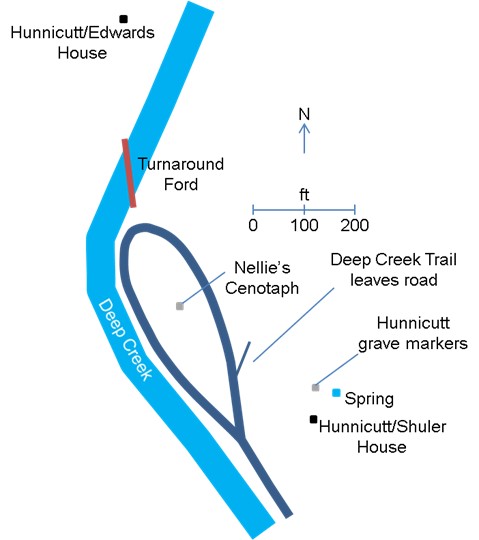
The section of the original Martin tract which Waitsel purchased is marked in yellow in Figure DC10. The reference to Indian Grave Ridge is the first that has been found. It continued to be used up until the time the land was taken by the N.C. Park Commission. A closer relative perspective which includes the elements noted below as well as the Turnaround road and ford locations is provided in Figure DC13.
 |
| Figure DC10. Original Martin Tract purchased by Spurgeon Hunnicutt, with the eastern section sold to his brother Waitsel highlighted and the Indian Grave Ridge which was part of the boundary noted. Map by author. |
Family patriarch, Marion Hunnicutt, died around 1904 and his son, Christopher Columbus Hunnicutt, died in 1923, per the Hunnicutt family. According to family tradition, father and son were buried on Indian Grave Ridge, just above the home which had been built there. The home was logically sited immediately adjacent to a spring.
On the other hand, the concept of siting a home in the middle of the almost level bottomland of the Turnaround, and also more than 100 yards away from a spring, would be at complete odds with virtually universal practice of Smoky mountain settlers, whether Cherokee or White. As Wendy and I have considered the overall layout of the Turnaround area, we have concluded that by far the most logical location for Nellie’s home was exactly the same location as that chosen by the Hunnicutts along the lower end of Indian Grave Ridge. The spring was right next to the house and siting the home there also didn’t occupy the most arable land. Conservation of bottomland was such a priority that the original road up Deep Creek was cut into the side of the hills in order to keep all of the best land free for raising of crops. The spring for the Waitsel Hunnicutt home – which we also believe to Nellie’s home – is shown in Figure DC11. Wendy Meyers is standing in the old road, which wound around the slope on the east side of the creek. The old wagon road begins on the east side of the former ford at the Jenkins Place and connects to today’s Deep Creek Trail at a rock wall which was built by the Hunnicutts, according to family tradition.
 |
| Figure DC11. Spring next to the Waitsel Hunnicutt home; Wendy Meyers is standing above the spring next to the old road which wound around the side of the ridge instead of along the precious bottomland. |
Waitsel sold the tract he had purchased from Spurgeon
to Ed and Mollie Shuler in 1925. They
retained ownership until the land was taken by the NC Park Commission. Another tract of land which had formerly been
owned by the Hunnicutts included the Turnaround proper as well as land on the
west side of Deep Creek. When taken by
the N.C. Park Commission, it was owned by Tom and May Edwards. The Park Commission report indicated it was “a
six-roomed ceiled and weather-boarded house in good (repair) located on three
acres of level land, beside the creek.”.
No one was living in the home, which was “being held for recreation
purposes.”
A
Serendipitous Homecoming
Around 2002, Jim Estes was walking up the Deep Creek trail to fish above the Bumgarner Bend when he encountered a fellow in his early 80s at the Turnaround. The older fellow had been fishing himself, but was seated on the log of a fallen tree waiting on a nephew to finish fishing. It turned out that the fellow was James Hunnicutt, the youngest son of Sam and Leah Hunnicutt. James was born at the mouth of Hammer Branch in 1921, but pointed Jim to where the family had last lived – at a home site on the other side of the old ford at the Turnaround. It was the six-room house mentioned in the Park Commission report. That home is one which was incorrectly marked on the 1931 map of the eastern section of the Park. That map showed the home on the eastern side of the creek, but both the N.C. Park Commission records and extant physical evidence (see Figure DC12) place it across the creek, near the Turnaround ford, as shown in Figure DC13. I likely would’ve never located that spot had it not been for Jim Estes passing along the personal memories of James Hunnicutt.
 |
| Figure DC12: Author with yellowbells/forsythia, chimney remains at the Hunnicutt home place across Deep Creek from the Turnaround. |
 |
| Figure DC13: Layout of the Turnaround area and features which have been discussed. Map by author. |
Jim Estes was himself raised on Deep Creek. His folks, including g-g grandparents Billy
and Sarah Louisa Morris and g-grandparents Goldman and Harriett Estes, were
living on Deep Creek when the Martin family moved to the Turnaround. His family knew the Hunnicutts well.
Those two sons of the Smokies had a homecoming-like sharing of memories of their common family lore. In the Figure DC14 photo, Sam Hunnicutt is standing at the left, with frying pan in hand. The man and woman to the right of Sam may be a Reeves couple, according to Jim Estes. Jim’s grandfather, Ellis Estes is on the horse. To the right of the horse are Tom Clark, Cora McCracken Estes (expecting Jim’s father, Jack, born in July, 1917), and Laura Estes Clark. Rena Cagle, the daughter of Lee and Annie Clark Cagle who Wendy wrote about previously is in the white hat behind unknown boys in front and Bonnie Rogers is to their right.
 |
| Figure DC14: Group of Deep Creek folks on a fishing outing. Photo courtesy of Jim Estes. |
Deep Creek calls its own
Deep Creek called to James Hunnicutt and Jim Estes,
for it is a place that calls its children home – to cast flies in holes named
by their forebears decades before, visit old home places, drink from the same
rocked-in springs that quenched the thirst of their ancestors, to recall their oft-told
tales and to simply remember.
The Places of Beard, Blanton, Bryson, Bumgarner,
Cagle, Casada, Cathey, Clark, Cline, Corn Tassel, Durham, Estes, Hunnicutt, Hyatt,
Jenkins, June Whank, Laney, Lollis, Martin, Massie, McCracken, Monteith,
Morris, Morrow, Parris, Queen, Randall, Shuler, Shytles, Styles, Swaim, Teague,
Thomas, Waycaster, Wiggins, and others are integral to the history of the Deep
Creek drainage.
Today, fallen chimneys, rock walls or foundation
stones, boxwoods, daffodils, yellowbells, japonica, mock orange and the like are
visual markers for the former home places.
They are all now Pondering Places, where in solitude or with a small
company, lives once eked out with the combination of a Protestant work ethic
and then common (now rare) know how are remembered. We owe it to them and ourselves to also
recall acts of sympathetic generosity like that of the Brysons for the Martin
family and the community at large.
Precious memories, may they linger….
_________________________________________
Sources:
Jim Estes, Wendy Meyers,
Annette Hartigan, Mike Aday, Ed and Dan Bryson, Jason Brady
NCPedia
article, Thomas, William Holland (gives date of him being
declared insane as March 1867)
NC Park Commission
Records, NC State Archives
Swain County Register of Deeds
Ancestry.com
Note: questions for the author of this piece, Don Casada, may be directed to him at doncasada@hotmail.com.


.jpg)
.JPG)


